> ## Documentation Index
> Fetch the complete documentation index at: https://docs.tilebox.com/llms.txt
> Use this file to discover all available pages before exploring further.
# Access USGS Landsat data
> Download USGS Landsat products with the Tilebox Landsat storage client, using Landsat 8 as an example.
Use this guide when you already have a Landsat datapoint from a Tilebox metadata query and want to access the product files behind it. The example uses Landsat 8 Collection 2 Level-2 surface reflectance data.
Tilebox indexes Landsat metadata as datasets. Product files remain in the USGS public cloud archive, so file access uses the `USGSLandsatStorageClient` and your AWS requester-pays setup.
## Prerequisites
* You have a [Tilebox API key](/authentication).
* You have installed the [Python SDK](/sdks/python/install).
* You have AWS credentials configured in your environment.
* Your AWS account can access [requester-pays S3 buckets](https://docs.aws.amazon.com/AmazonS3/latest/userguide/RequesterPaysBuckets.html).
```bash theme={"system"}
uv add tilebox shapely
```
USGS Landsat data is stored in a requester-pays S3 bucket. AWS charges for requests and data transfer according to your AWS account settings.
## Select a Landsat 8 datapoint
Start with a small metadata query and select one datapoint to access. For a deeper guide to open data discovery and metadata filtering, see [Query open data metadata](/guides/datasets/query-satellite-data).
```python Python theme={"system"}
from shapely import Polygon
from tilebox.datasets import Client
area = Polygon(
[
(-109.05, 37.0),
(-102.05, 37.0),
(-102.05, 41.0),
(-109.05, 41.0),
(-109.05, 37.0),
]
)
client = Client()
collection = client.dataset("open_data.usgs.landsat8_oli_tirs").collection("L2_SR")
scenes = collection.query(
temporal_extent=("2024-08-01", "2024-08-15"),
spatial_extent=area,
show_progress=True,
)
selected = scenes.where(scenes.cloud_cover < 10, drop=True).isel(time=0)
print(selected.granule_name.item())
```
## Create the Landsat storage client
Create a `USGSLandsatStorageClient`. The client uses AWS credentials from your environment, such as `AWS_ACCESS_KEY_ID`, `AWS_SECRET_ACCESS_KEY`, and `AWS_SESSION_TOKEN` when needed.
```python Python theme={"system"}
from tilebox.storage import USGSLandsatStorageClient
storage = USGSLandsatStorageClient()
```
## Download the complete product
Use `download` when you need the complete Landsat product directory. The storage client resolves the product location from the Tilebox datapoint metadata and downloads the matching files into the local cache.
```python Python theme={"system"}
product_path = storage.download(selected)
print(f"Downloaded {product_path.name} to {product_path}")
print("Contents:")
for path in product_path.iterdir():
print(f"- {path.relative_to(product_path)}")
```
```plaintext Output theme={"system"}
Downloaded LC08_L2SP_033033_20240808_20240814_02_T1 to ~/.cache/tilebox/collection02/level-2/standard/oli-tirs/2024/033/033/LC08_L2SP_033033_20240808_20240814_02_T1
Contents:
- LC08_L2SP_033033_20240808_20240814_02_T1_SR_B1.TIF
- LC08_L2SP_033033_20240808_20240814_02_T1_SR_B2.TIF
- LC08_L2SP_033033_20240808_20240814_02_T1_SR_B3.TIF
- LC08_L2SP_033033_20240808_20240814_02_T1_SR_B4.TIF
- LC08_L2SP_033033_20240808_20240814_02_T1_SR_B5.TIF
- LC08_L2SP_033033_20240808_20240814_02_T1_SR_B6.TIF
- LC08_L2SP_033033_20240808_20240814_02_T1_SR_B7.TIF
- LC08_L2SP_033033_20240808_20240814_02_T1_QA_PIXEL.TIF
- LC08_L2SP_033033_20240808_20240814_02_T1_MTL.json
- LC08_L2SP_033033_20240808_20240814_02_T1_thumb_small.jpeg
```
## Download selected product files
Landsat products contain surface reflectance bands, quality masks, thermal bands, metadata, and preview images. Use `list_objects` and `download_objects` when you only need specific files.
```python Python theme={"system"}
objects = storage.list_objects(selected)
rgb_bands = ["B4", "B3", "B2"]
rgb_objects = [
obj for obj in objects
if any(obj.endswith(f"_{band}.TIF") for band in rgb_bands)
]
for obj in rgb_objects:
print(obj)
downloaded_files = storage.download_objects(selected, rgb_objects)
print(downloaded_files)
```
Use this pattern when a workflow only needs a few bands, masks, or metadata files. It reduces transfer time and local storage compared with downloading the full product.
## Preview the product
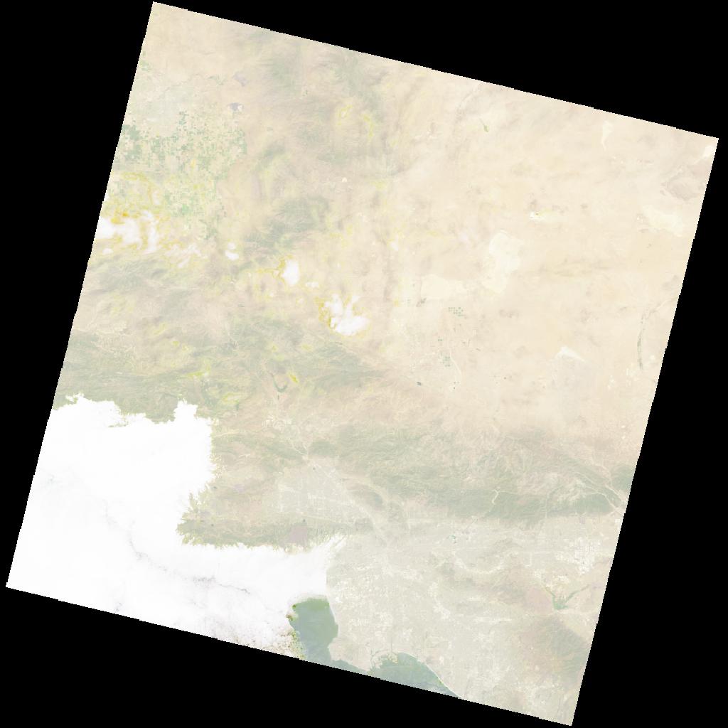
Many Landsat products include a thumbnail image. In a notebook, use `quicklook` to display the product preview without downloading the full product first.
```python Python theme={"system"}
storage.quicklook(selected)
```
 ## Next steps
Find Landsat products by time, location, and metadata fields.
Learn about the other Tilebox storage clients for open data products.
## Next steps
Find Landsat products by time, location, and metadata fields.
Learn about the other Tilebox storage clients for open data products.